Fire season roars throughout region
July 15, 2021
John Hamilton
THUNDERSTORMS last week sparked several fires throughout the Kootenai and Lolo national forests, including the Winniemuck and Thorne fires off of Blue Slide Road west of Thompson Falls.
The real fireworks waited until after July 4 this year.
Sparked by several thunderstorms carrying little precipitation but lots of lightning, over a dozen new forest fires sprang to life in Sanders County the morning of July 7, and several of them grew large quickly.
Viewing the larger picture in western Montana and northern Idaho, the local fires are part of a huge wildfire bust which is ongoing across the entire Pacific Northwest and other parts of the country. Recognizing the complexity of the situation with all the new starts and broad distribution of fires on their protection area, Lolo National Forest officials ordered in a Type I Incident Management Team (IMT), and a Northern Region team assumed command of the complex of fires, named the West Lolo Complex this past weekend (for current information please visit the #WestLoloComplex Facebook page and/or look up on the InciWeb fire site).
The West Lolo Complex team is tasked with the management of 10 of the more problematic fires on the Plains/Thompson Falls and Superior ranger districts.
A staggering total of 10 IMTs are assigned and on fires in the larger geographic area in this portion of Idaho and Montana right now, representing an unheard of amount of fire activity for this area this early in the wildland fire season.
To add to the local fire melee, a human-caused fire broke out on Montana DNRC protected land Sunday. Although not listed as contained yet, that fire, the Henry Creek fire, estimated at 200 acres at last count, was lined and about two dozen firefighters backed by engines, tenders and aerial support were still working on it Tuesday.
Although not as badly hit by the fire-causing storms as the Plains/Thompson Falls area, the Cabinet Ranger District on the county's west end and the CSKT Division of Fire lands on the eastern side of Sanders County also had several new starts, caused by lightning and humans, last week.
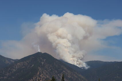
Of all the local fire starts, the Thorne Creek and Winniemuck fires, located about eight air miles northeast of Thompson Falls in the Graves Creek area, which are being managed as one incident, are the largest listed at a combined 1,012 acres as of Tuesday morning.
Located in steep, rocky, rugged terrain and burning in heavy, dead, downed forest fuels with no road access, the Thorne-Winniemuck fire has made several impressive runs, visible from Thompson Falls and the Clark Fork valley over the past several days.
As the fire poses an unacceptable risk to firefighter safety, managers have been closely monitoring the fire, scouting the perimeter seeking opportunities while attempting to develop a full suppression strategy for the problematic fire.
Speaking at a community meeting Monday evening in Plains, the operations chief for the team said the fire may be a long-term event that could be around for most of the summer. The fire had advanced to the Cube Iron Mountain area by early this week.
Another fire burning in the Graves Creek area on Cataract Peak south of Seven Point Mountain, which is also being managed by the team, is staffed, lined and listed at one acre after firefighters gained access to that blaze Monday.
A cluster of fires in the Cutoff area southeast of Paradise is also being managed as part of the West Lolo Complex in Sanders County.
The most challenging of those blazes, the Siegel fire is also burning in rocky, rugged, steep terrain and is currently holding at 20 acres. The unforgiving ground the fire is located on has made keeping the fire in check difficult as burning material has been periodically rolling out of the fire area and sparking spot fires outside control lines.
The Sheep Creek fire, up on the hill across the valley from Quinn's Hot Springs, is contained at three acres and crews are working toward putting that blaze completely out in the next several days.
The other fires being managed by the West Lolo Complex team are the Deep Lookout Mountain (listed at 303 acres) and Sunset (19 acres) fires on the Superior Ranger District. For more on those fires, visit the West Lolo Complex Facebook page or access Inciweb.
On the west end of the county, the Cabinet Ranger District picked up several starts in the last several days but have managed to catch them all. The Happy Gulch fire in the upper reaches of the Vermilion River reached five acres before being contained by Monday.

Penny Beckman
SMOKY SKIES and the setting sun made for brilliant oranges and reds over Plains on Sunday evening.
Smaller lightning fires in the Whitepine and Beaver Creek areas, and another on Dixie Peak have all been contained and/or controlled. A human-caused incident, the Swamp Creek fire burned 22 acres in grass before it was knocked down this past weekend.
On the east end of the county, the Little Money 2 fire, also started by lightning last week and right along the national forest/Flathead Indian Reservation divide, is being managed by the CSKT Division of Fire. That blaze, about eight air miles southeast of Paradise on the north side of the Flathead River, is listed at 159 acres with 35% containment.
Due to the extreme current fire danger in the area, the Sanders County Commissioners have voted to enact Stage II fire restrictions beginning Saturday, July 17 (see other story).


Reader Comments(0)